Mapping the groundwater vulnerability for pollution at the pan African scale
 |
report Nov 2015 ; 15 pages
Aut. Issoufou Ouedraogo & Pierre Defourny & Marnik Vanclooster
Ed. UCLouvain - Louvain-la-Neuve
Downloadable format: PdF
Downloadable from the publisher
 Thèse
Abstract:
Thèse
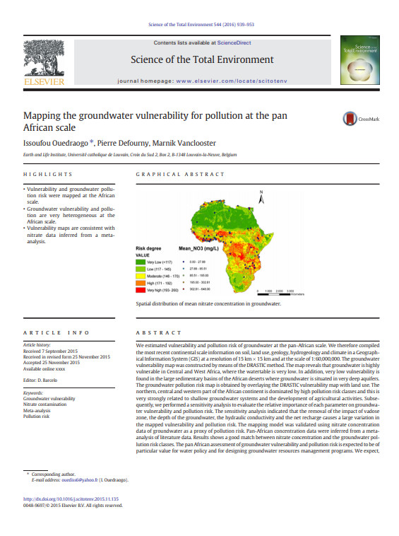
Abstract:We estimated vulnerability and pollution risk of groundwater at the pan-African scale. We therefore compiled themost recent continental scale information on soil, land use, geology, hydrogeology and climate in a Geographical Information System(GIS) at a resolution of 15km × 15 kmand at the scale of 1:60,000,000. The groundwater vulnerabilitymap was constructed bymeans of the DRASTIC method.
Target Audiences:
Keywords: |
access to water (CI) (DT) (ET) (ope) , Africa (CI) (DT) (ET) (ope) , management of water resources (CI) (DT) (ET) (ope) , water pollution (CI) (DT) (ET) (ope) |
Publisher/Broadcaster: |
|
UCLouvain
-
Université Catholique de Louvain - Louvain-la-Neuve - Belgium |
If there is a broken link, we will be pleased to receive a message: communication@pseau.org