Mapping the groundwater vulnerability for pollution at the pan African scale
 |
informe Nov 2015 ; 15 páginas
Aut. Issoufou Ouedraogo & Pierre Defourny & Marnik Vanclooster
Ed. UCLouvain - Louvain-la-Neuve
Formato descargable: PdF
Descargable desde el editor
 Thèse
Abstract:
Thèse
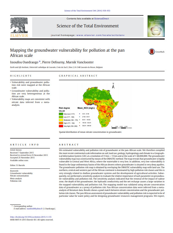
Abstract:We estimated vulnerability and pollution risk of groundwater at the pan-African scale. We therefore compiled themost recent continental scale information on soil, land use, geology, hydrogeology and climate in a Geographical Information System(GIS) at a resolution of 15km × 15 kmand at the scale of 1:60,000,000. The groundwater vulnerabilitymap was constructed bymeans of the DRASTIC method.
Destino Audiencia:
Palabras claves: |
acceso al agua (CI) (DT) (HP) (ope) , administración de recursos hídricos (CI) (DT) (HP) (ope) , Africa (CI) (DT) (HP) (ope) , contaminación del agua (CI) (DT) (HP) (ope) |
Editor/Difusor: |
|
UCLouvain
-
Université Catholique de Louvain - Louvain-la-Neuve - Bélgica |
Si hay un enlace roto, estaremos encantados de recibir un mensaje: communication@pseau.org